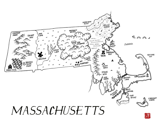
Massachusetts as a fantasy map
A downloadable map
The state of Massachusetts reimagined as a fantasy map. This map is part of the Integral States Project, an art series that encourages reflection about the actual, pre-colonial history of these landscapes as well as the indigenous peoples who called them home. Proceeds benefit native charities.
You’re very welcome to snag a free copy. Please rate if you like it to help others find these. Thanks! Prints are available at: https://www.redbubble.com/people/aldayuan
Project website: https://integralstatesproject.com.
The area that is now Massachusetts was inhabited by a variety of Algonquian speaking peoples including the Wampanoag (“eastern people”), Narragansetts (“people of the little points and bays”), Muhhekunneuw ("people of the great river”), and Moswetuset. The Wampanoag lived in what is now southeastern Massachusetts between the eastern shore of Narragansett Bay to the western end of Cape Cod, including the islands of Martha’s Vineyard and Nantucket. The Narragansett had winter long-houses in which multiple families lived as well as temporary summer shelters. They built large canoes from trees capable of holding forty people. The state’s name comes from the Moswetuset people, whose name means “near the great hill” or “hill shaped like an arrowhead,” and refers to a large arrow-shaped mound in what is now Quincy.
Download
Click download now to get access to the following files:
Leave a comment
Log in with itch.io to leave a comment.